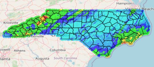
State Climate Office of North Carolina
MPE
NC DOT
Notice: Text message MPE alerts are unavailable. All alerts will be sent by email.

This website is funded, in part, by the NCDOT Highway Stormwater Program

Login with NCSCO ID

Don't have a NCSCO ID account?
Sign up here and then request access.

Precipitation estimates provided herein are derived from the NWS WSR-88D Doppler Radar. Radar preciptiation estimates can be grossly inaccurate, so radar-based precipitation values are calibrated with the routinely available hourly surface gages. The combined product provides the spatial resolution of radar with the increased accuracy of surface gage networks. These gage-calibrated radar estimates are known as Multi-sensor Precipitation Estimates, or MPE.
There are still errors in MPE. A study by the State Climate Office of North Carolina suggests that MPE compares well with an independent daily precipitation gage network over the Carolinas. Details of this study are available online.
The MPE grids used in this tool are routinely produced by the National Weather Service and National Centers for Environmental Prediction.
Mapping Application
Map
This simple mapping application enables you to visually see accumulated MPE estimates over time. When zoomed in, roads, water features, and town names can be overlayed for reference. Additionally, your project sites can be noted on the map for additional reference. The past 6, 12, 24, 48, and 72 hours are available to view spatially. 1-week, 30- and 90-day options are also available.
My Projects
My Projects + Alerts
This page shows a list of all projects that you are subscribed to receive precipitation alerts from. Each project has a list of associated sites. Accumulated MPE values are listed for all sites in text format. You can also manage your project alerts here. You can also view all projects.
New Projects
More Projects
This is where you can go to subscribe and unsubscribe to additional projects
Get More Data
Get More MPE Data
Quickly get the MPE values for any latitude/longitude in and around North Carolina.
Cardinal
Cardinal Data Request System
The latest online data retreival system of the NC State Climate Office. Cardinal integrates into the NCSCO's databases of hourly and daily surface weather observations from different weather networks in North Carolina